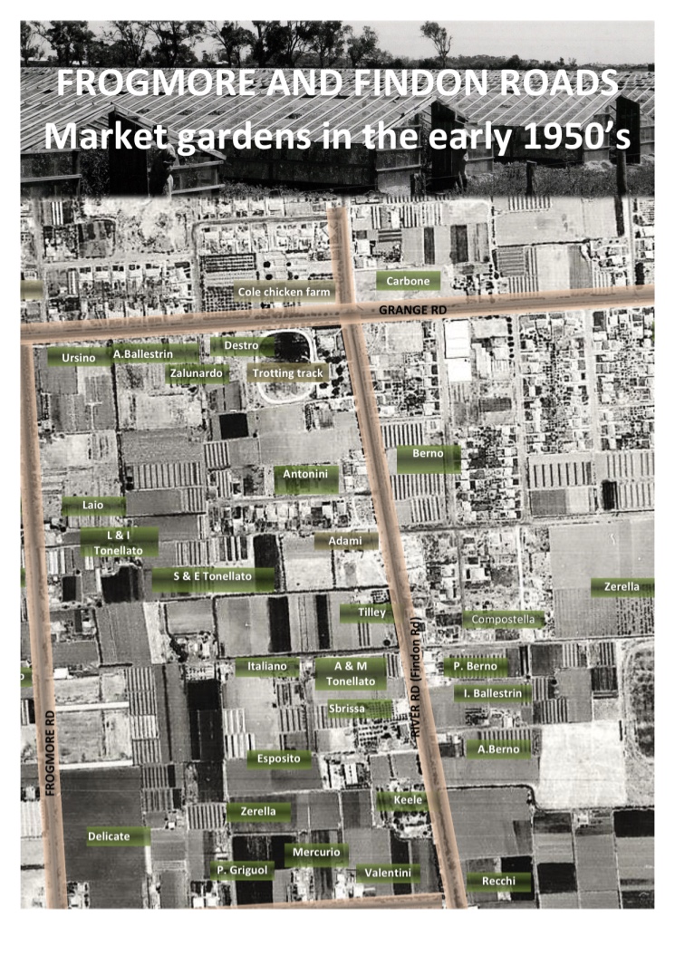
In 2007 I saw the first map of the Veneto market garden area in Kidman Park and Flinders Park where the Veneto families farmed. I met Johnny and Eleonora Marchioro at their market garden at Bolivar. Johnny drew a map to indicate where his father and mother, Vittorio and Angelina, had their market garden on Frogmore Road until 1948 when the family moved across the river to White Avenue Lockleys.
Johnny showed the locations where other veneti had their farms on Frogmore Road from the 1930s: the Piovesan’s, Tonellato’s, Santin’s, Zalunardo’s, the Berno families on Valetta Road and the Ballestrin families who worked farms near Findon Road from the early 1940s. There were other families farming in the area and Johnny marked them on the map; Fazzalari’s, Ursini’s, and on Valetta Road, Ballantyne’s and West’s and others. In that area there were extensive market gardens until the early 1970s. I did not know much about this piece of history of the western suburbs of Adelaide.

Map, courtesy, City of Charles Sturt
As the project developed, the City of Charles Sturt provided some great aerial photos of the area that were great resources to show the location of the market gardens. We could pinpoint them on the maps. The photos also showed the changes that have taken place in the area from the time of the first aerial view in 1935 when there was so much open land. The last one was taken in 2011. When you contrast two images taken 76 years apart you see the development of housing that has removed any signs of market gardens.
Gradually people have added the locations of their family market gardens at events that were held for the project. In 2013, we got lots of information at an afternoon in the Findon library and began several versions of the market gardens map. In 2017 Lino Ballestrin showed me a map he had drawn up that identified the various market gardening families in the 1940s and 1950s.
 When I was in Italy in 2018 for fieldwork, I took a copy of a photo showing the locations of family market gardens in the early 1950s. It was a pleasure to see the significance of the map to the people who had lived in the Frogmore Road, Valetta Road, Findon Road area many years ago.
Photo: Bruno Piovesan, Johnny Marchioro, Linda Lacey, Robert Tropeano
FIndon Library, May 2013
Nel 2007 ho visto la prima mappa degli orticoltori veneti nell’area del Kidman Park and Flinders Park dove le famiglie Venetae vivevono e lavoravano. Sono andata per incontrare Johnny e Eleonora Marchioro al loro orto. Johnny ha disegnato una mappa per indicare dove i suoi genitori, Vittorio e Angelina avevano il loro orto in Frogmore Road. Hanno vissuto lá fino al 1948 quando la famiglia si trasferì a White Avenue Lockleys.
Johnny mi mostrò la localitá dove altri orticoltori veneti avevano il loro orto negli anni “30”: le famiglie Piovesan, Tonellato, Santin, Zalunardo; le famiglie Berno a Valetta Road e le famiglie Ballestrin che lavorarano gli orti vicino a Findon Road nei primi anni “40”. C’erano altre famiglie Italiane che lavorarano nella zona e Johnny ha indicato nella mappa: Recchi, Ursini, Fazzalari ed anche le famigilie Ballantyne e West. Nella zona c’erano estensivi orti fino agli anni “70”. Non sapevo molto su questa storia dei sorborghi ovest di Adelaide e la contribuzione delle famiglie che hanno lavorato la terra.
Come il progetto si è sviluppato, il comune, the City of Charles Sturt, ha proveduto delle fotografie aeree della zona. Le mappe erano grandi risorse quando la gente parlava della localitá degli orticoltori perchè potevano vedere dove erano tanti anni fá. Dalle foto si poteva vedere il cambiamento che è avvenuto nella zona. Nella prima foto del 1935 si può vedere che c’era tanto terreno senza case. Il più recente che stata presa nel 2011. Il contrasto è evidente. Quando confronti le due foto prese 76 anni a parte, si può vedere lo sviluppo che stato fatto.

Gradualmente alle nostre reunion per il progetto la gente ha riconosciuto nelle mappe la località dove i loro genitori hanno lavorato e dove hanno vissuto. Nel 2013 abbiamo avuto le informazioni ad una nostra riunione nella biblioteca a Findon e cominicò parecchie version della mappa degli orticoltori veneti ed altri. Nel 2017 Lino Ballestrin mi ha mostrato una mappa che aveva disegnato e che identificava le varie famiglie di orticoltori nel 1940 e nel 1950. Tante sono le case costruite che non c’è traccia di agricoltura.
Quando ero in Italia nel 2018 lavorando sul progetto ho portato con me una copia della mappa indicando la località delle famiglie nei primi anni “50”. È stato un piacere vedere il significato che questa mappa ha avuto nelle persone che l’hanno vista. Cosi hanno potuto vedere dove i loro parenti ed altri hanno vissuto e lavorato tanti anni fà.